skip to main |
skip to sidebar
The Dalles Hydroelectric Dam
6:28 AM
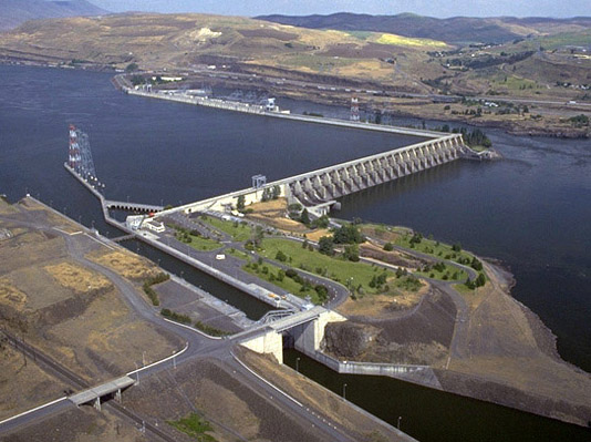
The Dalles Hydroelectric Dam is a concrete-gravity run-of-the-river dam spanning the Columbia River, two-miles (3 km) east of the city of The Dalles, Oregon, United States. It joins Wasco County, Oregon with Klickitat County, Washington, 192 miles (309 km) upriver from the mouth of the Columbia near Astoria, Oregon. The closest towns on the Washington side are Dallesport and Wishram.
The Army Corps of Engineers commenced work on the dam in 1952 and completed it five years later. Slackwater created by the dam submerged Celilo Falls, the economic and cultural hub of Native Americans in the region and the oldest continuously inhabited settlement in North America. On March 10, 1957, hundreds of observers looked on as the rising waters rapidly silenced the falls, submerged fishing platforms, and consumed the village of Celilo.
The reservoir behind the dam is named Lake Celilo and runs 24 miles (39 km) up the river channel, to the foot of John Day Dam. The dam is operated by the U.S. Army Corps of Engineers (USACE), and the power is marketed by the Bonneville Power Administration (BPA). It is part of an extensive system of dams on the Columbia and Snake Rivers.
The Dalles Dam Visitor Center is located at Seufert Park on the Oregon shore, and was built in 1981. Visitors used to be able to ride a tour train, which has been closed since autumn 2001. The closure is due to post-September 11 concerns, the deteriorating conditions of the tracks, and a small derailment of the train. The Columbia Hills State Park is nearby.
Specifications
- Altitude: 79 feet (24 m) above sea level
- Height: 260 feet (79 m)
- Length: 8,875 feet (2,705 m)
- Navigation lock:
- Single-lift
- 86 feet (26 m) wide
- 650 feet (198 m) long
- Powerhouse:
- Length: 2,089 feet (636.7 m)
- Fourteen 78,000 kilowatt units
- Eight 85,975 kilowatt units
- Total capacity: 1,779.8 megawatts
- Overload capacity: 2,038 MW
- Spillway:
- Gates: 23
- Length: 1,380 feet (420 m)
| The Dalles Dam | |
|---|---|
| Locale | Klickitat County, Washington / Wasco County, Oregon, USA |
| Dam and spillways | |
| Type of dam | Concrete gravity, run-of-the-river |
| Height | 260 feet (79 m) |
| Length | 8,875 feet (2,705 m) |
| Type of spillway | Service, gate-controlled |
| Power station | |
| Turbines | 22 |
| Installed capacity | 2,038 MW |
| Maximum capacity | 1,779.8 MW |