skip to main |
skip to sidebar
Showing posts with label Run of the River Hydroelectricity in US. Show all posts
Showing posts with label Run of the River Hydroelectricity in US. Show all posts
Lower Monumental Lock and Dam
7:27 AM

Lower Monumental Lock and Dam is a run-of-the-river hydroelectric dam on the Snake River, and bridges Franklin County and Walla Walla County, in the state of Washington. The dam is located six miles (10 km) south of the town of Kahlotus, and 43 miles (69 km) north of the town of Walla Walla.
Construction of Lower Monumental Lock and Dam began in June 1961. The main structure and three generators were completed in 1969, with an additional three generators finished in 1981. Generating capacity is 810 megawatts, with an overload capacity of 932 MW. The spillway has eight gates and is 572 feet (176 m) long.
Lower Monumental Dam is part of the Columbia River Basin system of dams.
Lake Herbert G. West, which extends 28 miles (45 km) east to the base of Little Goose Dam, is formed behind the dam. Lake Sacajawea, formed from Ice Harbor Dam, runs 35 miles (56 km) southwest, downstream from the base of the dam.
| Lower Monumental Dam | |
|---|---|
| Locale | Franklin / Walla Walla counties, Washington, USA |
| Construction began | June 1961 |
| Opening date | 1969 |
| Dam and spillways | |
| Type of dam | Concrete gravity, run-of-the-river |
| Height | 100 feet (30 m) |
| Length | 3,791 feet (1,155 m) |
| Impounds | Snake River |
| Type of spillway | Service, gate-controlled |
| Reservoir | |
| Creates | Lake Herbert G. West |
| Capacity | 32,266,666 cubic yards (24,669,636 m3) |
| Surface area | 6,590 acres (26.7 km2) |
| Power station | |
| Type | Yes |
| Turbines | 6 x 135-153 MW |
| Installed capacity | 810 MW |
| Maximum capacity | 932 MW |
Lower Granite Lock and Dam
7:22 AM

Lower Granite Lock and Dam is a concrete gravity run-of-the-river hydroelectric dam on the Snake River, and bridges Whitman County and Garfield County, in the U.S. state of Washington.[4] The dam is located 22 miles (35 km) south of the town of Colfax, and 35 miles (56 km) north of Pomeroy.
Lower Granite Lock and Dam is part of the Columbia River Basin system of dams. It was built and is operated by the United States Army Corps of Engineers. Power generated is distributed by the Bonneville Power Administration.
Lower Granite Lake, which extends 39-miles east to Lewiston, Idaho, is formed behind the dam. Lake Bryan, formed from Little Goose Dam, runs 37 miles (60 km) downstream from the base of the dam.
Construction of Lower Granite Lock and Dambegan in July 1965. The main structure and three generators were completed in 1972, with an additional three generators finished in 1979. Generating capacity is 810 megawatts, with an overload capacity of 932 MW. The spillway has eight gates and is 512 feet (156 m) long. An 86 x 674 ft. navigation lock was also included in construction.
Lower Granite Dam is the most upstream dam in the Snake River system that has fish ladders (2) to allow adult salmon and steelhead to migrate upstream. The Columbia River treaty tribes along with some environmental groups have recommended that this dam along with the other three lower Snake River dams be decommissioned and/or removed because of their impact on endangered salmon and steelhead populations. A significant increase in the Sockeye Salmon return to the Columbia River in 2008 proved a pleasant surprise and raised hopes for increased salmon runs across the Lower Granite. Wildlife officials were not certain of the reason for the increased salmon return (Idaho Statesman, June 28, 2008) The Army Corps of Engineers has installed new devices such as removable spillway weirs in an attempt to make the dam less harmful to juvenile salmon.
There is also a juvenile bypass/collection facility that collects juvenile migrating salmon and steelhead so they can be transported downstream by barge.
| Lower Granite Dam | |
|---|---|
| Locale | Garfield / Whitman counties, Washington, USA |
| Construction began | July 1965 |
| Opening date | 1984 |
| Construction cost | $624,098,663 |
| Dam and spillways | |
| Type of dam | Concrete-gravity, run-of-the-river |
| Height | 100 feet (30 m) |
| Length | 3,200 feet (980 m) |
| Impounds | Snake River |
| Type of spillway | Service, gate-controlled |
| Spillway capacity | 850,000 cubic feet per second (24,000 m3/s) |
| Reservoir | |
| Creates | Lower Granite Lake |
| Capacity | 710,189,333 cubic yards (542,978,705 m3) |
| Surface area | 8,900 acres (36 km2) |
| Power station | |
| Type | Yes |
| Turbines | 6 x 135-155 MW units |
| Installed capacity | 810 MW |
| Maximum capacity | 932 MW |
Little Goose Lock and Dam
7:19 AM

Little Goose Lock and Dam is a run-of-the-river hydroelectric dam in Columbia and Whitman counties in the state of Washington, on the Snake River. The dam is located 9 miles (14 km) northeast of the town of Starbuck, and 25 miles (40 km) north of Dayton.
Construction began in June 1963. The main structure and three generators were completed in 1970, with an additional three generators finished in 1978. Generating capacity is 810 megawatts, with an overload capacity of 932 MW. The spillway has eight gates and is 512 feet (156 m) long.
Little Goose Lock and Dam is part of the Columbia River Basin system of dams.
Lake Bryan, named for Doctor Enoch A. Bryan, is formed behind the dam. The lake stretches to the base of Lower Granite Dam, 37 miles (60 km) upstream. Lake Herbert G. West, formed from Lower Monumental Dam runs 28 miles (45 km) downstream from the base of the dam.
- Navigation lock
- Single-lift
- 86 feet (26 m) wide
- 668 feet (204 m) long
| Little Goose Dam | |
|---|---|
| Locale | Columbia / Whitman counties, Washington, USA |
| Construction began | June 1963 |
| Opening date | 1970 |
| Dam and spillways | |
| Type of dam | Concrete-gravity, run-of-the-river |
| Height | 98 feet (30 m) |
| Length | 2,655 feet (809 m) |
| Type of spillway | Service, gate-controlled |
| Reservoir | |
| Creates | Lake Bryan |
| Capacity | 832,964,000 cubic yards (636,847,000 m3) |
| Surface area | 10,025 acres (40.57 km2) |
| Power station | |
| Type | Yes |
| Turbines | 6 x 135-153 MW units |
| Installed capacity | 810 megawatts |
| Maximum capacity | 932 megawatts |
McNary Hydroelectric Dam
7:30 AM

McNary Hydroelectric Dam is a 1.4-mile (2.2-km) long concrete gravity run-of-the-river dam which spans the Columbia River. It joins Umatilla County, Oregon with Benton County, Washington, 292 miles (470 km) upriver from the mouth of the Columbia at Astoria, Oregon. It is operated by the U.S. Army Corps of Engineers' McNary Lock and Dam office. The dam is located a mile (2 km) east of the town of Umatilla, Oregon, and 8 miles (13 km) north of Hermiston, Oregon. The dam was originally planned to be named Umatilla Dam, but the Flood Control Act of 1945 renamed the dam in honor of Senator Charles L. McNary of Oregon, who had died the previous year.
The dam provides for slackwater navigation, hydroelectric power generation, recreation, wildlife habitat, and incidental irrigation.
Bills for the construction of a dam were introduced in the United States Congress as early as 1931. The United States House of Representatives rivers and harbors committee initially approved the project in April 1941; navigation, power generation, and national security were the major reasons cited for construction of the dam. Construction began in 1947, and was completed in 1954. Activation of all generating units was completed in 1957. Its capacity is 980 MW. There are two fish ladders for salmon and steelhead passage, one on each shore of the dam. The Washington side also has an 86 foot (26 m) wide, 683 foot (208 m) long navigation lock that lifts boats an average of 75 feet (23 m). The dam flooded the Umatilla Rapids, forming a reservoir called Lake Wallula. The lake extends 64 miles (103 km) up the Columbia to the US DOE Hanford Site. It also extends up the Snake River to the Ice Harbor Dam.
This McNary Hydroelectric Dam has a unique feature: two additional turbines whose purpose is to power the dam itself. That is, this dam is entirely self-sustaining; and if some large event caused the entire grid to go down, McNary would be key in getting it back on. These two "station service" turbines are only capable of providing about three MW, compared to the 70 MW of the other 14 turbines. These two turbines alternate service duty to provide the dam with its energy requirements.
McNary Hydroelectric Dam is part of the Columbia River Basin system of dams.
Statistic of McNary Hydroelectric Dam:
| McNary Dam | |
|---|---|
| Locale | Benton County, Washington / Umatilla County, Oregon, USA |
| Construction began | 1947 |
| Opening date | 1954 (Partial Activation) 1957 (Full Activation) |
| Dam and spillways | |
| Type of dam | Concrete gravity, run-of-the-river |
| Height | 183 feet (56 m) |
| Length | 7,365 feet (2,245 m) |
| Impounds | Columbia River |
| Type of spillway | Service, gate-controlled |
| Power station | |
| Turbines | 14 |
| Installed capacity | 1,127 MW |
| Maximum capacity | 980 MW |
Bonneville Lock and Dam
6:25 AM

Bonneville Lock and Dam consists of several run-of-the-river hydroelectric dam structures that together complete a span of the Columbia River between the U.S. states of Oregon and Washington at River Mile 146.1. The dam is located 40 miles (64 km) east of Portland, Oregon, in the Columbia River Gorge. The primary functions of Bonneville Lock and Dam are electrical power generation and river navigation. The dam was built and is managed by the United States Army Corps of Engineers. Electrical power generated at Bonneville is distributed by the Bonneville Power Administration. Bonneville Lock and Dam is named for Army Capt. Benjamin Bonneville, an early explorer credited with charting much of the Oregon Trail. The Bonneville Dam Historic District was designated a National Historic Landmark District in 1987.
Dimensions and statistics of Bonneville Lock and dam:
Dimensions and statistics of Bonneville Lock and dam:
- Owner: U.S. Army Corps of Engineers, Portland District
- Location: On Columbia River about 40 miles upstream from Portland, Oregon
- First Powerhouse – Constructed in 1933-37; Dam 313 m (1,027 ft) long x 77 feet (23 m) high forebay; 10 generators with an nominal total output capacity of 526,700 kW; Overload capacity 577,000 kW.
- Spillway – Constructed 1933-37; 18 gates over a length of 442 m (1,450 ft); maintains the reservoir (upriver) usually 18 m (59 ft) above the river on the downstream side;
- Second Powerhouse – Constructed 1974-82; Dam 300.5 m (986 ft) long x 77 feet (23 m) high forebay; 8 generators (plus two at fish ladders) with a nominal total generating capacity of 558,200 kW; Overload capacity 612,000 kW.
- Bonneville Lock – Constructed from 1987 to 1993 at a cost of $341 million; 26 m (85 ft) wide, 206 m (676 ft) long; transit time is approx. 30 minutes. Replaced earlier smaller lock built 1938.
- Lake Bonneville – 77 km (48 mi) long reservoir on the Columbia River created by Bonneville Dam; part of the Columbia-Snake Inland Waterway.
The fish hatchery and dam are open year-round from 9:00 am to 5:00 pm. It is best to visit the dam in the months of April through September when the salmon are more abundant.
There are fish viewing windows and visitors' centers on both the Oregon and Washington sides of the dam. Because of security concerns, visitors may be required to show ID, and it is not possible to cross the entire dam. During most of the year, more fish use the Washington shore fish ladders, so fish viewing may be better on the Washington side of the dam.| Bonneville Dam | |
|---|---|
| Locale | Columbia River Gorge National Scenic Area, Multnomah County, Oregon / Skamania County, Washington, USA |
| Construction began | 1934 (First Powerhouse) 1974 (Second Powerhouse) |
| Opening date | 1937 (First Powerhouse) 1981 (Second Powerhouse) |
| Dam and spillways | |
| Type of dam | Concrete gravity, run-of-the-river |
| Impounds | Columbia River |
| Type of spillway | Service, gate-controlled |
| Reservoir | |
| Creates | Lake Bonneville |
| Power station | |
| Type | Yes |
| Turbines | 20 |
| Installed capacity | 1092.9 MW |
The Dalles Hydroelectric Dam
6:28 AM
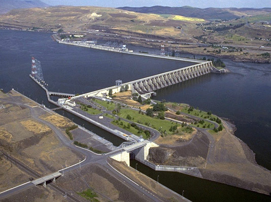
The Dalles Hydroelectric Dam is a concrete-gravity run-of-the-river dam spanning the Columbia River, two-miles (3 km) east of the city of The Dalles, Oregon, United States. It joins Wasco County, Oregon with Klickitat County, Washington, 192 miles (309 km) upriver from the mouth of the Columbia near Astoria, Oregon. The closest towns on the Washington side are Dallesport and Wishram.
The Army Corps of Engineers commenced work on the dam in 1952 and completed it five years later. Slackwater created by the dam submerged Celilo Falls, the economic and cultural hub of Native Americans in the region and the oldest continuously inhabited settlement in North America. On March 10, 1957, hundreds of observers looked on as the rising waters rapidly silenced the falls, submerged fishing platforms, and consumed the village of Celilo.
The reservoir behind the dam is named Lake Celilo and runs 24 miles (39 km) up the river channel, to the foot of John Day Dam. The dam is operated by the U.S. Army Corps of Engineers (USACE), and the power is marketed by the Bonneville Power Administration (BPA). It is part of an extensive system of dams on the Columbia and Snake Rivers.
The Dalles Dam Visitor Center is located at Seufert Park on the Oregon shore, and was built in 1981. Visitors used to be able to ride a tour train, which has been closed since autumn 2001. The closure is due to post-September 11 concerns, the deteriorating conditions of the tracks, and a small derailment of the train. The Columbia Hills State Park is nearby.
Specifications
- Altitude: 79 feet (24 m) above sea level
- Height: 260 feet (79 m)
- Length: 8,875 feet (2,705 m)
- Navigation lock:
- Single-lift
- 86 feet (26 m) wide
- 650 feet (198 m) long
- Powerhouse:
- Length: 2,089 feet (636.7 m)
- Fourteen 78,000 kilowatt units
- Eight 85,975 kilowatt units
- Total capacity: 1,779.8 megawatts
- Overload capacity: 2,038 MW
- Spillway:
- Gates: 23
- Length: 1,380 feet (420 m)
| The Dalles Dam | |
|---|---|
| Locale | Klickitat County, Washington / Wasco County, Oregon, USA |
| Dam and spillways | |
| Type of dam | Concrete gravity, run-of-the-river |
| Height | 260 feet (79 m) |
| Length | 8,875 feet (2,705 m) |
| Type of spillway | Service, gate-controlled |
| Power station | |
| Turbines | 22 |
| Installed capacity | 2,038 MW |
| Maximum capacity | 1,779.8 MW |
Subscribe to:
Posts (Atom)


